Flooding: How Can Cities Be Prepared for an Increasingly Unpredictable Future?

2018 was a year of unprecedented global weather events. In Asia, Super Typhoon Mangkhut brought close to $50 billion in damages to Hong Kong and China, on top of $16 to $20 billion it exacted from Philippines (Yap et al., 2018), while extreme precipitation-induced flooding in Kerala state killed at least 350 people and displaced over 800,000 (Kotecki, P., 2018). Meanwhile, 2019 started off with a historic deep freeze in the United States, brought about by unusual polar vortex formation (Channel News Asia, 2019).

Causes of climate change has long been associated with extreme events and is the biggest threat to the planet as reported by the World Economic Forum. Unless drastic changes are made to prevent global temperatures from rising more than 1.5 degrees Celsius, it is likely that we will continue to witness such events with increased magnitude and frequency. These events will continue to interact with complex systems, eventually set off their own ripple effects in a cascading manner akin to toppling dominoes (U.S. Global Change Research Program, 2018).

Introducing Resiliency in Global Warming

In the face of global climate change and diminishing natural resources, designing today’s cities and buildings require environmental, economic, and social considerations. The Rio Earth Summit in 1992 saw Sustainability at the forefront of many global policies aiming to minimize impacts on the environment. While Sustainability focuses on how we can slow down effects of global warming to the Earth, there is also a pressing need to look into the aftermath of warming – that has long been associated with extreme weather events. This is where we enter a new field known as “Resiliency”.

Importance of Resiliency Planning

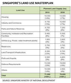
For the past 20 years, climate-related calamities accounted for 91% of all disasters, with floods topping the list at 43%. Direct economic losses within this period due to climate-related and flooding specific disasters brought about US$2,245 billion and US$656 billion worth of damage respectively (Crunch, C., 2018).  In terms of property value, a study by First Street Foundation (2019) has found that property values on the East and Gulf coasts of United States have reduced by $16 billion due to flooding threats, signaling that the market is already reacting to such disasters. Recent research in the field of attribution studies have further demonstrated that the frequency, intensity, and duration of natural disasters will continue to increase due to climate change (Achakulwisut, P., 2019).

And how do all these impact our lives and homes? How will our cities deal with such uncertainties of the future? Are we doing enough to overcome the challenges that lie ahead while mitigating risks? – The field of “Resiliency” attempts to shed light on planning ahead for such possible uncertainties of the future. From a broader perspective, resiliency is defined by the capacity of individuals, communities, institutions, businesses, and systems within a city to survive, adapt, and grow regardless of the kinds of chronic stresses and acute shocks they experience (100 Resilient Cities, 2019). From a flooding perspective, it is about how cities can plan for a flood-resilient future.

In light of recent severe events, and the risk of them occurring again, it is appropriate to consider how to assess flood risks in order to reduce the likelihood of flooding, and robust planning for a flood-resilient future. Such an approach usually considers the 4-R model developed by the Multidisciplinary Center for Earthquake Engineering Research (MCEER) at the University of Buffalo in the United States, which describes resilient systems as one that encompasses the following properties:

  1. Robustness (ability to withstand shocks, such as housing and bridges built to withstand flood waters)
  2. Redundancy (functional diversity, such as multiple evacuation routes)
  3. Resourcefulness (ability to mobilize when threatened, such as functional community groups who can quickly turn a community centre into a flood shelter), and
  4. Rapidity (ability to contain losses and recover in a timely manner, such as access to quick finance for recovery)

Digitisation Enables Us to Predict Flood Risks Unlike Before

The World Economic Forum 2019 in Davos with Industrialization 4.0 taking centre stage focused on digitisation, which enabled the interaction of multiple layers of data to generate insights and predictions unlike before. Such approach towards flood resiliency will transcend current approaches, which are currently conducted in a siloed, non-repeatable, and non-integrated fashion, as well as address currently missing key considerations, from specific geographies to the timing of storms that introduces complex compound flooding (Begos, K., 2019).

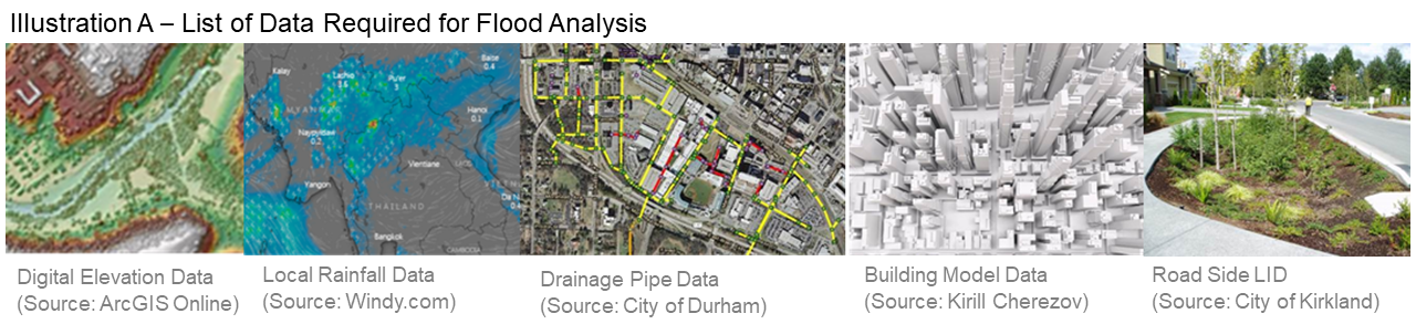
Our approach leverages on a common Geographic Information System (GIS) platform that brings together a multitude of data accurately geo-referenced to a single point, providing the basis that makes interaction possible. Among the comprehensive list of data required (refer to Illustration A) for such an analysis are topographical survey, building models, local rainfall, waterbody distribution, drainage network, and imperviousness data, that are most crucial for an accurate assessment.

Learning from Nature to Effectively Mitigate Flood Risks

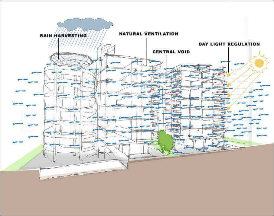
While embarking on digitisation endeavors and relooking at traditional approaches, we should not neglect processes that have worked brilliantly for billions of years – that is nature. By safeguarding natural buffers, we can leverage on them to enhance protective functions and confer disaster resilience. This is in line with the United Nations Disaster Resilience Scorecard for Cities (2017), as well as the Sendai Framework for resilient cities.

Since the last century, urban planning was focused on adopting a “pave, pipe and pump” methodology of storm water management (Knight, S., 2017), discharging them into sewers as soon as they make landfall. Recent unprecedented flooding events across the globe with effects intensified by both climate change and urbanisation have demonstrated that such an approach is no longer relevant. A softer approach should be taken, as opposed to solely upsizing and re-laying concrete pipes and sewers for every new flooding hotspot that occur (refer to Illustration B).

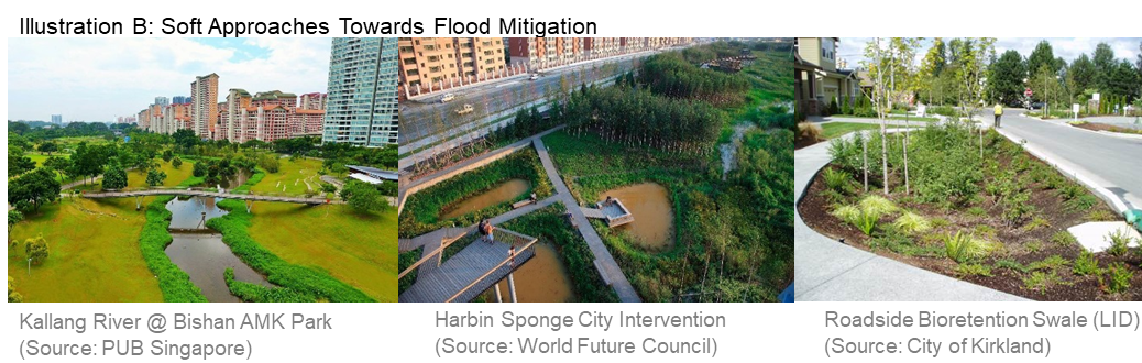
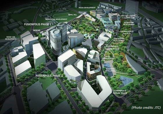
Termed as low impact development (LID), these flood mitigation measures mimic natural processes using solutions such as vegetated swales, rain gardens, wetlands, etc to absorb, infiltrate, diffuse, and convey stormwater runoff. Apart from reducing the peak flow rate of runoffs, they also improve water quality and enhance overall biodiversity and aesthetics of its site. Such projects have been gaining traction across major cities in United States, China, Australia, and Singapore, seamlessly integrating LID with architectural and landscaping elements to create biophilic “Sponge City” environments (refer to Illustration C).

The Next Frontier in Flood Resiliency Analysis

Given the high natural variability and underlying dynamics of climate, it is extremely challenging to model and predict flood risks. As such, before we can even consider flood mitigating solutions, it is imperative to consider how to precisely target existing and future flooding hotspots, evaluate the effectiveness of deploying a single or multiple array of solutions, and quantify the before and after flooding risks to arrive at a practical solution. On top of quantifying flooding risks and evaluating suitable mitigating strategies, digitisation enables us to visualise flood water propagation throughout every stage to facilitate informed decision making.

Our flood risk analysis is applicable for projects ranging from small-scale plot level developments, to mid-scale district zones, and large scale urban planning projects – providing tailor-made flood resilient solutions for every client. A combination of resultant flooding hotspots, water depth indication, and animation of flood water propagation interacting with topography and physical obstructions provide for multiple angles of analysis.

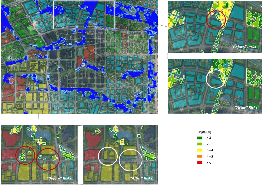
When capacities of storm sewers, drains, and rivers are exceeded during a precipitation event, stormwater runoff will start propagating to low lying areas that can be visualised in a flood propagation animation that varies with time. Together with a flood risk map, this enables planners to precisely determine which zones are at risk, evaluate a combination of suitable mitigating solutions or re-locate critical zones to less flood-prone areas, effectively taking guesswork out of their design. A demonstration can be seen in figures below, showcasing “before” and “after” flooding risks. Such optimization can potentially save the many lives that have been lost in recent extreme precipitation events by putting effective measures in place beforehand. Afterall, investing in pre-event resilience building is more cost-effective than simply cleaning up after a disaster.

Illustration C: The City’s Flood Risks from a 1 in 50 Years Precipitation Event, Before and After Incorporating Mitigating Solutions such as LID and enlarged drainage pipe sizes. Multi-Coloured Spots Outlined in White (with legend on the right) Demarcates Depth of Water Ponding. (Regions circled in RED indicates potential flooding hotspots on land. Regions circled in WHITE indicates problem of flooding has been reduced/resolved.)


Our Smart Approach Towards Flooding

During actual deployment, real or near real time sensors can be considered in conjunction with weather cameras to provide data to monitor flooding situations. Such data is first input to a sensor fusion platform which is then fed into our model, after which the output is visualized in the city or estate operations control centre for the controller to activate or even automatically trigger certain emergency processes such as evacuation, road closure or traffic diversion. Nearby safe shelters or medical facilities locations and information can be communicated to the public via mobile applications or roadside display panels.

Furthermore, the flooding analysis model can also be integrated into a digital twin of the physical environment to allow other systems to be built on it, interacted and tested to a certain confidence level before rolling out to the actual environment. This helps to continuously train and update the model with real-time information to make it more intelligent and robust for detection and triggering of future events. The flood analysis model can help to fine tune the placement of sensors through testing in the digital twin environment to increase the availability or accuracy of data, or even better communicate to the public in the event of an emergency. Through this exercise, it helps the city or development agencies better plan and manage an emergency event from the input of data, triggering of actions and communication to the public. Ultimately, calibrated digital twin enables for far more effective real-time operational decision making and control, that also facilitates risk prediction and defining the best course of action to prevent communities from being taken by surprise (Begos, K., 2019).

Conclusion

Moving forward to a future with an increasingly uncertain climate, there needs to be a paradigm shift in the way cities are planned and designed, using such flooding analysis to provide certainty for our future cities to become flood resilient, and smart tools to provide real-time information to facilitate decision making. In doing so, we are not only building cities, but also shaping the lives of those people who live in them.

REFERENCES:

100 Resilient Cities (2019). Defining Urban Resilience. Retrieved from: https://www.100resilientcities.org/

Achakulwisut, P., (2019). Climate Change is a Public health Emergency. Scientific American. Retrieved from: https://www-nature-com.proxygw.wrlc.org/articles/s41558-018-0315-6

Begos, K., (2019) Local Flood Forecasting Has Been Dangerously Imprecise – That’s About to Change. Scientific America. Retrieved from: https://www.scientificamerican.com/article/local-flood-forecasting-has-been-dangerously-imprecise-mdash-thats-about-to-change1/

Channel News Asia (2019). More than 20 dead in US polar vortex, frostbite amputations feared.

Retrieved from: https://www.channelnewsasia.com/news/world/more-than-20-dead-in-us-polar-vortex-frostbite-amputations-11194248

Crunch, C., (2018). Economic Losses, Poverty & Disasters 1998 – 2017. US Agency for International Development

Disaster Resilience Scorecard for Cities (2017). United Nations Office for Disaster Risk Reduction.

First Street Foundation (2019). Rising Seas Soaked Home Owners for $16 Billion Over 12 Years. Scientific American. Retrieved from: https://www.scientificamerican.com/article/rising-seas-soaked-home-owners-for-16-billion-over-12-years/

Knight, S., (2017) What would an entirely flood-proof city look like? Retrieved from: https://www.theguardian.com/cities/2017/sep/25/what-flood-proof-city-china-dhaka-houston

Kotecki, P., (2018). Natural disasters set records around the world in 2018. These were some of the worst. Business Insider.

Retrieved from: https://www.businessinsider.sg/worst-natural-disasters-records-world-in-2018-2018-11/?r=US&IR=T

List of Data Required for Our Flood Analysis Includes:

Aquifers, building models, climate, discharge locations, drainage network, flow diversions, imperviousness data, land use, LID design parameters, local rainfall, manhole design, orifices, outfall locations, pumps, river flow centrelines, storm water storage tanks, subcatchments, topographical survey, waterbody distribution, and weirs.

U.S. Global Change Research Program (2018). Fourth National Climate Assessment. Retrieved from: https://nca2018.globalchange.gov/

Yap et al., (2018). Hong Kong On Lockdown as Typhoon Mangkhut Arrives. Bloomberg.

Retrieved from: https://www.bloomberg.com/news/articles/2018-09-14/super-typhoon-mangkhut-slams-philippines-with-category-5-power

Special thanks to the following who have actively contributed to the article:

Adam Kua ZhengJie
Engineer
Sustainability and Resiliency Office

Yi Huilin
Engineer
Sustainability and Resiliency Office

Martin Lim Huat
Principle Project Manager
Sustainability and Resiliency Office

Energy & Petrochemical Parks – Creating Value Through Robust Land Leasing Approaches

BP recently reported[1] that in 2017, global primary energy consumption recorded a robust 2.2% growth rate, outpacing the 10-year average of 1.7% per year.  Oil, coal, and natural gas remained the dominant fuel sources, together accounting for over 80% of all energy consumed whilst renewable power hit a new high but still modest 3.6% by contribution.  Prospects for the downstream petrochemical sector are even stronger. In May 2017, Independent Chemical Information Service (ICIS) forecasted that global petrochemical demand[2] would accelerate to an average annual growth rate of 4% between 2015 and 2025.

Energy & Petrochemicals – A Land-Intensive Sector

This sector is both energy and capital-intensive, and coupled with safety considerations, it is also characterised by its land-intensive nature as well.  Europe hosts many of the world’s most developed and mature petrochemical manufacturing parks. The land sizes of these parks range from a few hundred hectares to thousands of hectares.  For example, Infraserv’s park in Frankfurt occupies nearly 500 hectares of land (equivalent to 610 football fields), on which sits a network of over 500 kilometres of pipelines carrying chemical liquids and gases.

Planning for investment in such specialised parks can be a painstaking process. And decisions are made on the assurance that pre-conditions, such as the ability to secure a plot of land, shall be met. Greenfield investments typically require several hectares of land, and the extent to which production processes and equipment can be re-designed to save land is limited by codes of practice and regulatory considerations.

Therefore, in securing land for the investment, an investor’s priorities would certainly include:

  • Adequacy of land tenure – at a minimum, tenure must exceed the targeted Return on Investment time period, and generally the intention is to stretch the tenure for as long as possible;
  • Securing contiguous land for expansion – a strong investment plan is one that anticipates a sales exceeding supply within a few years from start-up, thus justifying a de-bottlenecking of capacity in the near or mid-term; and
  • Availability of land for long-term growth.

The land owner naturally desires to unlock potential and tap the maximum value of the land, and often also look towards generating growth from a range of consequential economic activities.

This translates into the following priorities for industrial land owner:

  • Sustainable economic activities – existence of sustained industrial manufacturing activities that generate economic benefits;
  • Judicious use of the land – appropriate use of the land that coincides with original plans, and is not wasteful. It should also be compatible and synergistic with its neighbouring activities; and
  • Preservation of its overall environmental climate – the environmental baseline of the piece of land should not go into deep deterioration due to industrial usage.

Robust Land Leasing Frameworks

The importance of the land lease process is often either overlooked or under-estimated.  Rather than being considered a repetitive procedure, land lease management should be viewed as an effective, customisable tool to secure assurances for all parties and shape the manufacturing landscape.

How can a land owner meet an investor’s expectations on land tenure, availability and flexibility, while at the same time, preserving his priorities on the sustainable use of his land?

Land tenure for the manufacturing sector varies across different territories.  For example, in China, the government’s land regulations[3] stipulate a maximum tenure of 50 years for industrial land. While in Singapore, the tenure of industrial land issuance[4] through Industrial Government Land Sales was halved to 30 years in 2012[5]. Typically, industrial land leases range between 20 or 30 years long[6].  In some other countries, industrial land is sold in perpetuity.  For land tenure to be meaningful, it should be long enough and commensurate with the sector’s life cycle, as well as consider the level of capital expenditure on fixed production assets.  At the same time, the tenure should permit park rejuvenation or redevelopment.  Therefore, it would be advisable to first understand such sectoral characteristics. Then, we can determine the standard tenure to be offered to investors in any specialised park.

To ensure that the land is put to good and proper use, the land owner can specify and build into the land lease, mechanisms to motivate the investor to invest and build as planned, intensify land use, and even reinstate and return the land when it is no longer needed. Through the skilful crafting of the leasing process and the lease document itself, issues such as under-development or land contamination (SSI’s site in the U.K.[7]) can be avoided. In certain situations, leasing mechanisms could be designed holistically with other levers, such as incentives, to achieve win-win outcomes.

Ensuring adequate availability of land, especially contiguous land for expansion, is partly an outcome of good master-planning, but also heavily dependent on how robust the land leasing processes are.  The allocation of a land plot for future development does not have to be binary.  Carefully customised land reservation programmes provide investors with sufficient assurance whilst retaining the land owner freedom to commit unused land to other suitable investors when the time comes.

The description of approaches above hopefully provides an insight into the importance and versatility of land lease management.

An Important Differentiating Factor for Land Owners

As Nobel Prize winner Elias James Corey once said, the impact of chemical synthesis “on our lives and society is all pervasive.”  Whether we like it or not, the energy and petrochemical sector is an integral contributor to the lifestyles that we’ve gotten used to.  Energy and petrochemical parks are specialised and complex ecosystems that occupy enormous land masses for long periods of time.  A best-in-class land leasing framework is an essential tool for any energy and petrochemical park to thrive, and is an important factor in differentiating a forward-looking land owner amongst others.

This article is co-created by Surbana Jurong Academy.


[1] Report titled “BP Statistical Review of World Energy”, 67th Edition, dated June 2018.

[2] Made up of major categories Polyolefins, Polyesters and Polyurethanes, Key Elastomers, and Other Key Plastics. From slide 19 of ICIS’ presentation dated 18 May 2017 titled “Accelerated Changes: New Scenarios for the Global Refining and Petrochemical Industries, and the Role of China” at APIC 2017.

[3] Regulations on the Land Use Rights and Transfer of State Land Use Rights in Urban Areas of the People’s Republic of China /《中华人民共和国城镇国有土地使用权出让和转让暂行条例》of May 1990.

[4] In 1947, a ruling known as the Crown Lands Rules was passed, in which Rule 16 proclaimed that 99-year leases would be issued, in place of Statutory Land Grants (which were freehold).

[5] Ministry of Trade and Industry’s press release titled “Launch of Second Half 2012 / Industrial Government Land Sales Programme” dated 11 June 2012.

[6] Channel NewsAsia’s news article, “How Singapore’s 50-year-old land sales programme is evolving” dated 13 December 2017.

[7] In Teeside, Sahaviriya Steel Industries (SSI) went into liquidation, marking the end of almost 170 years of iron and steel making. A 14-hectare portion of its former site is likely to be highly contaminated by heavy metals due its former industrial usage, and this would affect the future usability of the land. Source: South Tees Development Corporation, South Tees Regeneration Master Plan consultation draft, dated October 2017.

Creating a Petrochemical Hub – Vision versus Reality

The petrochemical industry is capital-intensive and has the potential to draw investments of multi-billion dollars. While the industry takes a significantly long period to develop, it also produces the highest economic returns and offers high value-add positions with good remunerations, compared to other sectors. Based on Exxon Mobil Energy Outlook 2018, the global population will grow to 9.2 billion by 2040. And rising living standards and expanding worldwide population means a higher dependence on reliable modern energy.

Global energy demand will continue to be driven significantly by oil & natural gas. As demand continues, many petroleum-rich countries have transformed from a sole exporter of natural resources, to a downstream petrochemical refiner or manufacturer, adding value to their energy exports. For some, their ambition went further. They create manufacturing clusters, with an objective to build a petroleum or petrochemical hub at a later stage. But, having natural resources and the ability to process it for export does not necessarily fulfil the requirements of a hub creation. Based on Surbana Jurong Pte Ltd’s experience in developing Jurong Island Chemicals Hub, and many other petrochemical manufacturing sites and production zones globally, there are critical factors that will influence the success of a petrochemical hub.

Positioning – Where is the Market?

The vision to create a petrochemical hub should fundamentally be supported by market demand (Please refer to illustration 1 for Success Factors in Creating a Petrochemical Hub). The foremost requirement would be to meet the domestic demand of the country which produces the natural resources. When the domestic demand is insufficient to justify the development of the petrochemical hub, then having wider and regional, or even global captive markets would be necessary.

Building petrochemical plants, especially a crude oil refinery, can take between six to seven years to complete. Hence, investors and business owners will need to be forward-thinking, and be able to anticipate future demands and predict trends for a time frame of at least 15 to 30 years.

Targeting the right sub-sectors for the petroleum and chemicals industry are equally critical. Some countries may yield oil and no gas, while others gas and no oil, or both. Identifying the right sub-sectors to focus, and subsequently forming the value chain to synergize with associated industries can be challenging in the absence of good foresight, marketing and in-depth industry knowledge.

The definition of a “hub” does not necessarily mean that it must be geographically built within a single location. The hub can consist of several manufacturing or logistics sites that leverage on their synergistic and strategic natural advantages, bringing benefits to consumers. The availability and ease of obtaining and transporting the natural resources, such as connectivity through pipelines, ports of call, are important factors to consider.

Petrochemical Hub oil & gas
Illustration 1: Success Factors in Creating a Petrochemical Hub

An Implementable Master Plan to Secure Investor’s Buy-In

Considering the huge investment involved in this capital-intensive industry, it will be worthwhile to meticulously plan and chart out the strategies and development roadmap to minimise risk, and ensure success.

We then ask ourselves these questions:

  • Have we understood enough in terms of projecting the market demand and our competitive advantages?
  • Have we identified the different types and capacities of processing & manufacturing plants?
  • What are the logistical requirements needed to ensure sustainability?
  • What are the sub-sectors and supporting industries within the value chain?
  • What are the other land uses, preparatory requirements needed, infrastructure & connectivity, and amenities?
  • Is skilled human capital available, and are safety and environment issues resolved?

These factors shall form the backbone of an overall master plan for any hub. The overall master plan must be comprehensive, sustainable and most importantly, implementable.

Every country, city or district compete for major investments to support economic growth and create employment. The stakes can be high and in most cases, incentives and preferential policies are provided to attract investors. However, when competitors offer similar incentives, the difference in attracting major investments could boil down to having a differentiating and well thought-through overall master plan.

Government’s Role – A Balancing Act

The role of the Government in the development of a petrochemical hub is often contestable. Policies that promote investment and instil investors’ confidence will trigger positive influence on the vision. The Government therefore needs to take on a strategic view to grow the economy, improve employment and employability of the people.

For a hub development, it would be instrumental for initial land preparations and infrastructure investment to be provided by public sources, and preferably to continue through for all basic infrastructure investment. Thereafter, the growth of the hub should ideally be driven by the private sectors operating within a realm of pro-business ecosystem.

The question of whether Government should partake in any business venture, such as processing plants, is often debated. Production sharing agreements between public and private sectors for upstream exploration and production of natural resources can be contested from time to time. The role of the Government in downstream sectors should be preferably limited to creating a conducive environment for businesses to prosper, and at most, participating in a significantly minority stake to instil investor confidence and for risk sharing with investor. Where critically necessary, the Government could also take the lead in developing critical infrastructure necessary to support the growth or attraction of new investment.

The ability to ensure the continuation of policies despite political uncertainties or changes will further improve investment confidence and ensure investors of the political will to realise the vision of a hub.

Closing the Expertise Gap during Execution

Having a comprehensive overall master plan that captures the essence of attracting investment is important, but more imperative is the ability to facilitate subsequent implementation. The most challenging aspect of implementation is the high stakes involved when major public investment in infrastructure should rightfully yield positive impact on attracting private investment.

Creating and institutionalising a platform where functions such as marketing, planning, project management, lease management, customer service, health safety & environment, legal and finance congregate, would help in areas of strategizing and alignment. It also allows efficient servicing of investors and ensure effective implementation of the overall master plan. As there will always be expertise gaps in functions, investing in expertise and capacity building will be the long term solution to support the vision.

The realisation of a petrochemical hub is constantly challenged by market volatility, geopolitics, bureaucracy, new technologies and competitions. Yet, harnessing and leveraging on the wealth of natural resources, and utilising them efficiently and sustainably, is ever more critical in the changing global landscape of digital & circular economy. Ultimately, the petrochemical hub, when realised, should improve the quality of lives of its citizens and bring prosperity to the country.

This article is co-created by Surbana Jurong Academy.

Structural Engineering – Getting Ready for the Future!

Structural Engineers are always in competition with the nature. Every creation has a co-relation with things that we see around us. A simple leaf shows how nature has provided each component its desired position and purpose. A leaf acts like a simple cantilever, the soffit of which is under compression. Figure 1a shows the leaves of a banana plant. The thicker midrib at the bottom very efficiently resists the tension.

Figure 1a: Leave of a Banana Plant (the thicker midrib at the bottom resists the tension)

A top view of the same leaf is shown in Figure 1b. It is clear from this figure that the midrib has a cross-section, like a U beam. This acts as a channel for the rain water to flow from the leaves. With this configuration, the top portion of mid rib can take only tensile forces. It can buckle with compressive forces as the top portion is thin.

Figure 1b: Midrib of leaf has a cross-section like a U beam

Nature has kept everything in the right place. Similarly, a building is analogous to a tree with its foundation as roots and so on. In this way, engineers are influenced by nature. Each one’s achievement and victory is measured relative to others around them. The same holds true of our performance which is measured against our competitor’s.

A designer’s vision is restricted within such limits, nature and people at the start of a design. As a structural engineer, we need to see beyond what is around us. This would help us stay ahead in race.

Analysing the Past

Throwback to 15 years ago, would anyone have imagined the accomplishments we have made today? From what some of the seniors recollect, no one then imagined that drawings could be completed as fast and easy as one can nowadays. There was resistance from many draftsmen to learn drafting software like AutoCAD (in 2D). The ones who adapted to the change had persisted in the industry.

Today, it is difficult to find an office where draftsmen are involved in manual sketching. In addition to this change, we are in a decade where we move a step ahead and are creating 3D drawings/illustrations which are useful for the engineers to visualize these structures as it will be on-site.

Figure 2: Bridge 3D model – Dedicated Freight Corridor Project India

In structural engineering practice, technology has played a crucial role in solving complex problems, considering the project’s time constraints and the need for accuracy. Previously, engineers used to spend enormous time calculating huge stiffness matrices for multiple elements of structures on sheets spread across the room, and preferred to take a conservative approach to avoid unnoticed errors.

The transition from manual calculation to using simple programmes formulated in FORTRAN and C, to advanced finite element (FE) packages that could analyse the entire structure within a short time is a classic example of our development. The difference between the FE software used then and now could be the level of analysis depth we intend to look at. The 3D visualisation and displacement, and stress plots of the same nowadays make them user-friendly as well.

In a project, the designer and the technician work side by side for two outputs, i.e. a model for analysis and design, and a drawing for site. Coordination between themselves and updating the comments from the reviewer on both these outputs consume more time. As for the future, we could expect a scenario where a 3D print of the structure could be generated simultaneously when the designer completes the analysis. This will help save time, and avoids duplication of the structure modeling.

Value Engineering

The advancement in technology has opened up new opportunities for engineers from non-structural practice. Some work done by structural engineers could be easily automated by any individual with fundamental knowledge about the software. This may give the impression that the presence of structural engineers may be less important when similar work can be automated using a computer.

“As structural engineers, we play a critical role in the projects for which we are appointed. If success is judged simply against the need to provide adequate resistance to collapse, then we are very successful, but the value we can bring to a project goes far beyond that.”

As an engineer, it is our responsibility to help the future stay sustained with the current developments in the society. To achieve this, we need to ensure that the design we propose is optimised and the materials are reusable. Proposing aesthetically pleasing and yet complicated designs may help us stand out in this competitive world. But, are such outcomes really necessary, and if safety standards are compromised?

Figure 3: Marseille Vieux Port, France

Figure 3 shows us a simple and elegant design of a canopy. There is no additional design made to suit the aesthetics that served no purpose. As an Engineer, we need to challenge our client, and convince them of a superior, yet sustainable design that is functional.

By designing elements that could be disassembled after its design life, we not only increase the life span of individual elements, but also help in the easy replacement of those that are damaged.

Collaboration

Inevitable development in transportation like the ‘hyperloop’ would require collaboration of engineers from multiple disciplines. Keeping ourselves abreast with the progressive development made in other disciplines will help us stay on top. With software incorporating Building Information Modeling (BIM), there is a chance of fewer errors when information from various disciplines can be collated on a single platform.

The algorithms which power the Google search engines someday will serve as a background for design. With a large database of designs and clever learning algorithms, we are in a generation whereby just giving a few parameters as input on a design/analysis problem, we could extract the complete design prediction. This can be a useful tool wherein large number of identical structures must be designed.

When such technologies come into existence, we need to move a step forward, and think outside our codal provisions. The existing codes consider an ideal scenario where unforeseen changes in the climatic conditions4 are not considered. For example, the design for earthquake is based on average spectra of all the seismic activities from the past. With increased Global Warming, there is a potential risk that these past records of natural calamities may not be captured. In such cases, we may have to adopt ‘performance based design’ where the capacity versus demand is assessed based on the occupancy level for the design of that structure.

FIB Model codes serve as a basis for future codes with up to date research activities. They help in challenging our understanding of structural behavior from multiple perspectives, supplemented with background information on every formulation and application rule set by codes.

Conclusion

Engineering is a combination of simple physics and little bit of common sense.”

Before the Tacoma Narrows Bridge collapsed, structural engineers never considered the importance of aero elasticity in civil structures. It was the time spent in digging through the lessons learnt that created such magnificent bridges and skyscrapers. We need to be open to interdisciplinary collaboration challenging our wisdom, and strive to work towards a sustainable future.

This article is co-created by Surbana Jurong Academy.

References

[1] Roger plank, President of the Institution of Structural Engineers (2011), Annual Presidential Address

[2] Roger Ridsdill Smith, Head of Structural Engineering and Senior Partner at Foster + Partners, IABSE Annual Milne Medal Lecture.

[3] Guglielmo Carra- Three ways structural engineers can help create a zero-waste future, Institution of Structural Engineers blog

[4] Caroline Field, Engineering for the future – a resilience based approach, Institution of Structural Engineers resources center

[5] A.D Pandey, Assistant Professor (Retd.), Indian Institute of Technology, Roorkee India

The Key Success Factors of Special Economic Zones

There are thousands of Special Economic Zones (SEZs), industrial parks, export processing zones and other similar areas globally. Some are successful in generating significant economic activities. But many are not. Why?

I believe that ultimately there are 5 key success factors for SEZs and other industrial parks:-

  • Clear Objectives;
  • Bold Policy Innovations;
  • Good Locations;
  • Customised Designs; and
  • Effective Management.

Clear Objectives

First, it is most important to be clear about the specific objectives of setting up the SEZ. The usual reasons include:

  • Creation of jobs, especially when there is significant unemployment;
  • Promotion of exports to generate foreign reserves, when there is a shortage of foreign reserves and a trade deficit;
  • Development of specific industries, eg the tourism sector;
  • Technology transfer.

While these reasons need not be mutually exclusive, we should recognise that it will not be easy for one SEZ to fulfill all these objectives at the same time. So, it is important to identify the most critical rationale for setting up the SEZ. And given the reasons, the strategies then become clearer. For example: If one should target foreign Multinational Corporations (MNCs) or local companies, should the sector focus be on manufacturing, or services.

For instance, for many developing countries, creating employment for the masses is critical. In such instances, an obvious strategy is to attract labour-intensive manufacturing activities or to promote the services sectors that are suitable given the education level of the population. However, too often, many government authorities become distracted by the glamour of attracting high-tech industries, which have a high degree of automation and may not create many jobs, thus defeating the purpose of setting up the SEZ in the first instance. The lack of clarity of objectives and an inability to remain consistent, often results in a SEZ that did not accomplish the objectives, but is also unsuccessful.

One of the most successful SEZs is the Shenzhen SEZ in China, started in 1980, when China first opened up its economy. At that time, China was in the midst of an ideological shift from central planning to a market economy. The Shenzhen SEZ thus served as an experiment for China to test out market-based reforms. The objectives were clear and the corresponding policies, such as tax incentives and more liberal business policies were implemented to facilitate these objectives. Even today, Shenzhen remains as one of the most dynamic and innovative cities in China.

Another example is the China-Singapore Suzhou Industrial Park (CSSIP) which was set up in 1994 for China to learn and implement some of Singapore’s industrial development policies. Specifically, it was dedicated to developing an export-oriented manufacturing sector in Suzhou targeted at foreign MNCs. A dedicated government was set up to administer the park and various foreign investment-related policies were liberalised based on Singapore’s experience. Today, the CSSIP is one of the top industrial parks in China in terms of industrial output, exports and value-added with more than its fair share of global Fortune 500 companies.

Bold Policy Innovations

Having identified the objectives of the SEZ, the next step is to boldly formulate new policies or liberalise existing regulations. A common failure for many SEZs is to hold back on the necessary policy innovations because of fear of liberalising too quickly. This is unfortunate because the idea of setting an area as a SEZ is precisely to allow for experimentation and liberalisation without affecting the rest of the country. To be successful, the SEZ must inspire confidence that it will be different from other parts of the country. Some typical policy innovations or liberalisations include:

  • Taxation – Tax holidays or reduced tax rates is probably the first policy innovation for many SEZs. The Chinese industrial zones have used the tax policy of “Two years free of tax, three years at half rate” (liang mian san jian) effectively for many years. Besides corporate income tax, other taxes such as GST and personal income tax can also be tools for liberalisation within SEZs.
  • Customs regulations – These refer to the exemption or reduction of import tariffs as well as the simplification of customs clearance procedures on goods imported into the SEZ. This is especially relevant for SEZs that are set up to promote exports. The Airport Logistics Park of Singapore (ALPS) is a good example of how customs regulations can be liberalised to stimulate the growth of the air logistics sector.
  • Labour policies – Where there is a shortage of manpower, labour policies may have to be liberalised to allow influx of migrants, be it from overseas or from other parts of the country.
  • Financial flows – In countries where there are foreign exchange and capital controls, the SEZ may be a location where such restrictions can be lifted. If stronger promotion is required, low interest loans can even be provided in the SEZ.

Good Locations

The location of the SEZ is another important consideration. If a SEZ is meant to generate exports, then its proximity to ports and airports will be crucial. If the SEZ is meant to develop the manufacturing sector, then its proximity to a suitably educated labour force will determine how successful it will be. If the SEZ is meant to develop the downstream processing industries, eg, food processing, then it should be sufficiently near to farms and plantations. If the SEZ is meant to cater to the local markets, then obviously access to the local consumer is key. Other considerations when choosing a location are the availability of supporting industries and amenities such as banking, dormitories, schools and healthcare.

Too often, the SEZ is seen as the answer to raising the standard of living in an area. However, the remoteness of the area, without much access to raw materials or export channels, may mean that the SEZ is set up for failure. A more practical solution may be to set up the SEZ in a more suitable location and allow people to migrate there over time.

Customised Designs

The masterplan and design of the SEZ must be done carefully to compensate for what the location lacks, to cater to what the investors desire, to address the government’s concerns and to integrate with the surrounding area. Too often, this step is overlooked or done too hastily, resulting in subsequent haphazard developments.

First, the masterplan needs to examine the current state and the future requirements of core infrastructure of the SEZ and its surrounding area. For instance, it needs to study the state of connectivity of the SEZ by roads, railways, ports and airports, and determine if more infrastructure needs to be built to enhance connectivity. It also needs to project the future energy needs to ensure that there will be sufficient power as the SEZ grows. And where necessary, plans should be made to develop more power generation and distribution capacity. Other utilities such as telecommunications, water and waste treatment should be similarly examined.

Second, the masterplan needs to cater to the target investor. An automotive park will need large parcels of land, while a logistics park will have big warehouses and an electronics manufacturing SEZ may need smaller built-up factories. For certain SEZs, having access to low-cost utilities is an important consideration and must be designed into the masterplan. For instance, in Singapore, the Jurong Island petrochemical complex has common utilities such as water and gas supplied centrally to the various investors in the complex. The One-North Innovation District of Singapore caters to the bio-medical science and high-tech industries. And it is designed to create an atmosphere of casual vibrancy which stimulates creativity and imagination.

Third, the masterplan and factory design should also take note of the government’s concerns. For instance, in land-scarce Singapore, land productivity is important. Building upwards to optimise on productivity is therefore an important aspect of the design of the factory. Even warehouses can have multiple levels with docking bays on different levels to enhance land productivity in Singapore.

Finally, the masterplan must be well-integrated with the surrounding area and compensate for the lack in amenities such as housing, schools and healthcare facilities. Sometimes, an entire township needs to be master-planned and developed next to the SEZ.

Effective Management

SEZ should last for decades and its benefits may only be felt years after it is built. The long-term management of the SEZ therefore must be efficient and effective. The management team needs to remain true to the vision of the SEZ, adhere to the masterplan and yet have the confidence and flexibility to cater to changes in customer demands, demographics and technology advances.

Increasingly, SEZs are managed on a PPP basis. This implies that the SEZ management may be a private sector company. The contractual agreement between the SEZ management company and the government, and the revenue model of the SEZ management are then important to ensure the long-term sustainability of the SEZ.

The interface between the SEZ management and the government is another important issue for SEZs. A high level of autonomy for the SEZ is usually desirable. This allows the SEZ to be free from the constraints of the other government departments which have regulatory responsibilities in their respective areas but do not necessarily feel obliged to support the SEZ.

Finally, the experience and global network of the SEZ management will be key in determining the success of the SEZ. A management team that has experience dealing with SEZ issues and a large pool of potential investors to promote the SEZ to will be a valuable partner. (Please refer to diagram 1 for a Summary of Key Success Factors of SEZs).

Special Economic Zones
Diagram 1: Summary of the Key Success Factors of SEZs

Conclusion

SEZs can be an effective programme for economic development. However, many fail because of confused objectives, timid policy liberalisation, bad choice of location, poor designs or ineffectual management. On the other hand, if the SEZ has clarity of vision, bold policy changes, a carefully chosen location, clever designs and strong management, then it has a good chance of success.

This article is co-created by Surbana Jurong Academy.

Perspectives, developed by SJ Academy, is our platform to explore new ways of tackling some of today’s most complex challenges. We draw on ideas and opinions from our staff associates and experts across different businesses. Click here to read more about Technology & Innovation, Infrastructure & Connectivity, and Design Leadership.

Persistent under-development of infrastructure – How can we solve it?

Many infrastructure developments around the world fall into a state of unfulfilled excess demand and derelict, due to improper planning. Teo Eng Cheong, CEO (International), discusses the importance of developing an Infrastructure Roadmap, and what various stakeholders need to look out for when planning for such huge project investments.

Introduction

By all measures, the demand for infrastructure investment is huge. The Global Infrastructure Outlook estimates that from 2016 to 2040, $94 trillion of infrastructure investment is needed globally, of which about $50 trillion would be required in Asia. An investment gap of about $15 trillion is expected based on current trends.

The benefits of infrastructure are obvious, bringing about an improvement in living standards. It gives a short-term boost to the economy through higher GDP and employment. More importantly, it lays the foundation for longer-term increase in productivity and more sustainable economic growth.

Financing for infrastructure is available from International Financial Institutions (IFIs) like World Bank, Asian Development Bank, Asian Infrastructure Investment Bank, as well as from National Financial Institutions, particularly those from Japan and China, like Silk Road Fund, Japan International Cooperation Agency (JICA) and Japan Overseas Infrastructure Investment Cooperation (JOIN).

Private infrastructure funds are also keen to provide financing for bankable projects. At the same time, many engineering companies have incentives to design, build and operate infrastructure on a commercial basis. The Belt-and-road initiative has further unleashed much capital and technical expertise onto infrastructure development. Yet, in many parts of the world, infrastructure remains sorely under-built, poorly constructed and often accompanied by large amount of wastage.

Reasons for Under-developed Infrastructure

I believe there are a few reasons why infrastructure is often in a state of unfulfilled excess demand. First, the long duration of infrastructure development is a major factor. Infrastructure typically takes a long time to plan, design and build. If it is done on a Public Private Partnership (PPP) basis, the concession period required for payback will take even longer, usually decades. This implies that whatever legal framework and contracts that the infrastructure developers and operators rely on, they must stand the test of time, even when the counterparties – usually governments – change hands. This uncertainty may result in a risk that is too high for many infrastructure developers and operators.

A second reason is that infrastructure development often requires compromises from various segments of the population. It often requires the acquisition of land from land owners. It may lead to years of disruption for the community as the infrastructure is being built. Even after completion, it may lead to increased pollution or other negative impact for the surrounding areas. The government would need to be persuasive enough to convince the affected parties to accept these compromises for the greater good. Governments without strong enough support from the population may find this difficult to accomplish.

Finally, infrastructure development is often complex, both in its financing structure as well as in its technical designs. It is often not possible to foresee all the complications that may arise in the course of any infrastructure development. It may be unexpected soil condition or environmental issues which are not detected earlier. Or it may be a financial crisis which throws the financial model out of the window. This requires flexibility in government responses during implementation. However, flexibility without adequate governance may also lead to corruption or other fraudulent activities. Unfortunately, some governments are not well-equipped to handle such complex changes, resulting in badly constructed infrastructure with budget overruns and delayed timeline.

All these reasons may increase the level of uncertainty of infrastructure projects to the point where both the government and the private sector investors back off.

Suggestions for Improved Planning

First, each government should develop an Infrastructure Roadmap, clearly identifying what infrastructure is needed to support its economic and social development vision and strategies. The Roadmap should coherently prioritise its infrastructure needs in the short and long term. Please refer to diagram 1 for an example of an Infrastructure Road Map. Besides explaining the benefits of the infrastructure projects, the Roadmap should also explain the necessary trade-offs, be it acquisition of land or co-payment for utilities or imposition of government fees to cover these costs, etc. Such a Roadmap would give IFIs the confidence that the government knows what it is doing and encourage them to finance such projects. The Infrastructure Roadmap should also be widely publicised to the population to get its support and to commit the current and future governments to adhere to the roadmap. IFIs which finance infrastructure projects may want to push for the governments they work with to move towards developing such Roadmaps. Hopefully, in the near future, voters would expect all responsible governments to have thoughtful and implementable Infrastructure Roadmaps.

Singapore infrastructure road map
Diagram 1: Example of Infrastructure Road Map featuring industrial space allocation

Each government should also appoint a group of officials dedicated to implementing the Infrastructure Roadmap. These Infrastructure Officials may include well-trained planners, economists, engineers and managers. These officials may be organised as staff in one agency or they may simply be working in close collaboration across agencies. Whatever the structure, there should be coordination and cross-fertilisation of ideas and learning. The officials should be sufficiently empowered to overcome resistance from interest groups, whether they are government agencies or external parties. And they should be sufficiently independent from short-term political considerations. These Infrastructure Officials must ensure that the government gets its value for money spent on infrastructure. But they must also be pragmatic and recognise that without sufficient returns, no investors will finance infrastructure development.

Finally, the legal framework of infrastructure development, eg, that related to land acquisition, property rights, contracts and investments, must be developed and institutionalised. It is important that the government build up its legal ecosystem and relevant institutions to ensure that its contracts will be honoured, corruption will not be tolerated, and companies and individuals will be treated fairly in courts of law. Certainty in the commercial aspects of infrastructure projects will be strengthened if there is the rule of law in the country.

Only when there is certainty will infrastructure projects take off.

If a government has a coherent Infrastructure Roadmap, which is well-executed by an empowered group of Infrastructure Officials under a well-enforced legal framework, it has a good chance of developing its infrastructure to the benefit of its people.

This article is co-created by Surbana Jurong Academy.

Perspectives, developed by SJ Academy, is our platform to explore new ways of tackling some of today’s most complex challenges. We draw on ideas and opinions from our staff associates and experts across different businesses. Click here to read more about Technology & Innovation, Infrastructure & Connectivity, and Design Leadership.

High Rise, High Density Complexes – The Future of Singapore’s Industrial Landscape?

Multi-level industrial buildings are commonly found in land-scarce countries. They are developed in response to high industrial land prices and rents, and suit tenants whose operations have higher throughput volumes.

 As we see the upward trend of building such multi-tiered complexes in land scarce Singapore, Ms Siah Puay Lin, Deputy Director of Surbana Jurong Infrastructure Pte Ltd, shares insights on the feasibilities and strategies of Singapore’s industrial landscape and its future.

Q1: In a nutshell, how has Singapore’s industrial landscape evolved since the country’s Independence? 

A: During the 60’s and 70’s, Singapore attracted labour intensive industries and provided ready-built standard factories to facilitate speedy set-up for the companies – local and foreign. Economic growth and job creation were seen in quantitative terms, based on the number of jobs that could be created and the amount of foreign investment that could be attracted. Two distinct forms of industrial environments emerged during this time:

  • large industrial estates in the rural parts of Singapore;
  • light industrial estates located close to housing estates or fringing the central area.

The 80’s saw the development of Singapore into a modern industrial economy. It resulted in a shift to capital and technology focused industries with a better-equipped work force and higher capabilities. To support and meet the needs of new businesses, the type of industrial parks that evolved took on a new dimension:

  • Upgrading and refurbishing of industrial parks through new product creation;
  • Purpose-built science parks and business parks. These parks are set in high quality environments catering to the needs of modern businesses.

The birth of Information Technology in the 90’s saw many businesses competing to increase their worth in the value chain. Advancement in technology also meant industrial developers had to find ways of addressing new business needs.

The 90’s also introduced “stack-up factory” – a new building typology that Jurong Town Corporation (JTC) came up with, designed to intensify land use by stacking standard factories on top of one another to create multi-storeyed factories. The use of ramps to gain access to upper levels allowed occupants to enjoy the same convenience as those at ground level – for loading/unloading goods.

By the millennium, the path towards a full-fledged knowledge-based economy was clearer. In tandem, the master planning of industrial land adapted new concepts such as ‘industry clustering’ and ‘integrating Live-Play-Learn environments’. A good example is the 200-ha One-North estate which features mixed-use industrial spaces. Its Vista Exchange area was designed and developed into a lifestyle, business, hotel, entertainment and transport hub.

Q2: How has the role of an architect / industrial urban planner changed over the different periods?

A: The architect/planner has had to adopt a multi-dimensional approach to solving problems. He/she has had to have a deeper understanding of industry needs as well as the effects of technological advances. He/she then has had to translate these into the built environment – not merely by checking for compliances – but by going beyond to provide more flexibility, cost effectiveness and to create healthy work environments.

Q3: The 2010’s is seeing Land Intensification Strategies being rolled out. Please share how industrial developers are creating more spaces within a same plot of land.

A: An example of how intensely single plots of land are used is the Jurong Rock Caverns, Southeast Asia’s first underground liquid hydrocarbon storage facility that goes as deep as a 9-storey building. It helped to solve problems of oil storage and made available land for further industrial expansion.

Besides building downwards as in the case of Jurong Rock Caverns, the drive towards more urbane and smart solutions with regards to building typologies was accelerated to allow companies to build higher and utilise available space optimally.

The other example is the consolidation of similar industrial facilities and common amenities – to eradicate duplication and optimises valuable space for production needs. We implemented this in our projects in One North (Biopolis), CleanTech and Medtech Hub by providing centralised utilities and common facilities unique to the target industries.

The 8-Storey Sin Ming Auto City is a continuum of the revolutionary concept and design where motor workshops are fully-integrated and operate under a multi-tiered industrial complex – providing one-stop vehicular solutioning, meeting motor repair needs and maintenance services in an up-to-date, clean and modern environment. It comprises 14 heavy vehicle units, 117 motor workshop units and 30 spray painting units.

Q4: Using the 8-Storey Sin Ming Auto City as an example of smart building solutioning in land-scarce Singapore, please discuss the integrated approaches to spatial planning for such industrial complexes.

A: The 8-storey Sin Ming Auto City boasts of passive design strategies that enhance the work and living environment through the staggering of the building mass, and the introduction of air-wells – bringing in good daylighting and ventilation. The concept of “work-live-play-learn” resonates as part of the build plan in 2012.

All units are fitted with an ancillary mezzanine office and dedicated workers’ living quarters – providing on-site living accommodation to workers. Ensuring that the respiratory health and living standards of workers in the complex are not compromised, ventilation and exhaust shafts for expulsion of engine emissions were carefully integrated (please refer to illustration 1 for the building’s approach to total sustainability). The building also holds essential amenities such as a staff canteen, a recreational centre, and convenience store.

Sin Ming Auto City
Illustration 1: 8-Storey Sin Ming Auto City: Porosity of the building mass excellent natural ventilation throughout; response to sun orientation and rainwater harvesting capitalise passive design strategies as an approach to total sustainability.

The introduction of balconies, self-sustaining vertical greening and rainwater harvesting further enhance green building initiatives, making it an all-inclusive eco-system. (The Sin Ming Auto City was awarded Gold for Building and Construction Authority’s Green Mark in 2015). Please refer to illustration 2 for the building’s green initiative.

Sin Ming Auto City rainwater harvesting
Illustration 2: 8-Storey Sin Ming Auto City: Rainwater harvesting tanks visually expressed as funnels to enhance the eco-system.

Q5: Multi-tiered industrial buildings seem to be the way to go for Singapore’s industrial landscape. How different is it to design and plan for residential estates versus industrial estates?

A: Planning objectives are similar in that we are essentially building for people and creating communities. The former would require provisions that meet the needs of families and individuals, and how they will interact and contribute positively towards the good of the larger community. The necessity for schools, town centres, parks, recreational and neighbourhood amenities must be considered; and this is underscored by good traffic network, transportation, utilities network and internet connectivity.

In the same way, the industrial estate needs to be planned for the work and business community – with good traffic network, transportation, and the appropriate utilities provisions. It has to be sensitive to the type of business, products and workforce it serves in and around the estate precinct. Clustering of similar industries is important as it allows for systematic planning, and adequate provisions for shared facilities and amenities – all to be made from the onset.

Q6: Are there existing global industrial projects which are modelled after Singapore’s?

A: Building upon our legacy from Jurong Town Corporation (JTC), Surbana Jurong has been successful in many overseas industrial park projects – Suzhou Industrial Park, Tianjin Eco City Business Park (please refer to illustration 3), Qatari FTZ and Logistics Park (Qatar), iCAD (Abu Dhabi, UAE), to name a few, are shiny examples of how other cities are replicating Singapore’s industrial park models.

tianjin eco city business park
Illustration 3: Tianjin Eco City Business Park (Urban Design Landmark Building)

Q7: So, what holds for the Future of Singapore’s Industrial Landscape?

A: Industrial building designers have probably taken on new forms of industrial clustering/planning during modern times, and this may not necessarily be confined to the traditional spatial concentration of similar industry companies in a particular location.

Similarly, such innovation continues for new industrial estates delving into newly found industries. By gaining insight on the nature of the industry’s value chain and operational standards of companies, industrial infrastructures are shaped to provide the tangible framework – and each company operating in it is then able to generate synergies amongst themselves to form an industrial community with a competitive edge.

Tracing how Singapore’s industrial landscape has evolved over the years, we observe how each decade’s economic and land policy mechanisms function. This, combined with physical planning and urban design initiatives, will in turn influence the focus in planning and design principles of industrial estate typologies. As such, the result of the physical form, as well as the interaction and functioning of Singapore’s industrial estates, has seen a progressive transition from the past till present, with each decade adding on a new dimension to the industrial built environment in Singapore.

Singapore’s industrial landscape development will continue to be driven by land intensification, new technologies and the emergence of new industries. Even farming and food business businesses are going high-rise. Buildings will be designed for ease of maintenance; hence the use of BIM for facility management will gain in popularity. Overall and increasingly, new industrial estates and buildings will and must become more eco-friendly as well as society-friendly. Not only must we not pollute and make the best use of resources, we must cater to an aging population and special-needs groups.

This article is co-created by Surbana Jurong Academy.

Perspectives, developed by SJ Academy, is our platform to explore new ways of tackling some of today’s most complex challenges in the urban and infrastucture sector. We draw on ideas and opinions from our experts across different businesses. Click here to read more about Technology & Innovation, Connectivity & Infrastructure, and Design Leadership.

Surbana Jurong’s journey into one-north

Twenty years ago, Singapore set out a daring ambition: to build on its position as South East Asia’s premier global trading center and establish itself as a world leading knowledge hub. Throughout this journey, Surbana Jurong’s expertise has helped to guide the project from vision towards reality.

Singapore has always been a nation with ambition. Never more so in the 1990s, a new plan emerged to transform this small island nation from an independent, world leading trading center, into a global, knowledge-based economy.

The ambition required a new type of infrastructure. A purpose-built environment to attract the new breed of fast-growing information and intelligence-based industries and research and development companies – to create a world leading destination to which global talent and entrepreneurs naturally gravitated and turned their visions to reality.

The one-north development zone is the result of this ambition. It builds on the cluster strategy originally proposed in the late 1990’s by the Singapore’s National Science and Technology Board, now renamed A*Star (Agency for Science, Technology and Research). The name one-north itself is intended to reflect the scale of ambition. Originally called simply the Buona Vista Science Park, it was rebranded as one- north to reflect Singapore’s location 1 degree north of the Equator, and designed to avoid the vision of one-north being defined by its locality or the word Science.

It was a collaborative initiative involving various statutory boards and government agencies which formed a steering committee to guide direction and chart the roadmap for implementation. The committee comprised members from the Ministry of National Development (URA, HDB), Ministry of Law (Singapore Land Office), Ministry of Trade and Industry (EDB, JTC Corp) and Ministry of Transport (LTA). JTC Corporation took the leading role of developing and implementing the project.

The mission was clear: To gather and encourage communities of likeminded businesses, focus investment and create technology hubs dedicated to research and development. The master plan was envisioned as a mixed-use development incorporating different Work-Live-Play-Learn elements.

Long term partnership and collaboration
World renowned architect, the late Zaha Hadid, was commissioned in 2001 to produce the master plan and created a framework and concept for the development. However, throughout this 17-year project evolution, Surbana Jurong has been at the heart of work to create the physical manifestation of Hadid’s grand master plan. It was gradually realized through tangible buildings and infrastructure, with every stage reshaping the built environment to meet the needs of the community.

Each project in the development has presented unique challenges. As such the projects clearly highlighted many critical elements of the firm’s philosophy and approach to planning, design and construction.

Community is key. One unique feature for one-north is the requirement for all developers to invest in public artwork worth a minimum of 0.5% the construction cost of the project. The result is an art accessible and culturally rich area to which businesses and the community is drawn, underlining the mixed-use characteristics envisaged by the master plan and the organic growth of one-north.

Throughout this time, the work has evolved to reflect the various phases of developments in the diverse land use clusters and its industrial “epicenters”: from the initial Phase Z.ro start-up catalyst incubators, to the Biopolis biomedical research centers, Fusionopolis info-communications technology,  and data center.

Vision for the future – Phase Z.ro

Building out this bold masterplan required JTC as the developer and Surbana Jurong its appointed consultant to lead a clear vision to kick start construction of the vast one-north development site. This began with the Phase Z.ro (pronounced Zee-Ro) development which effectively started the project, acting as a catalyst for development and an incubator for start-up technology companies.

This rapidly erected start-up cluster, located adjacent to the Ministry of Education headquarters, was constructed in 2001 from reused shipping containers and originally designed for just three years of temporary use.

The goal was to create a rapid, new and exciting buzz around the site; to draw in technology companies and so promote the one-north sector as next big moment in Singapore’s development. The project comprised 60 steel shipping containers stacked two units high, with common circulation spaces and shared amenities weaved between – designed and delivered at fast-pace to mirror the constantly changing and growing ethos of start-up technology and IT companies.

Tenants were provided with high speed broadband connectivity, shared meeting rooms with teleconferencing facilities, security and maintenance services. The development also doubled as JTC’s on site office as the next phases of one-north were rolled out.

Slightly later than intended, the offices were dismantled in 2008 with the containers and other components recycled for new uses. However, this interim and temporary use of the site had, in effect, set out the vision for the project as the breeding ground for new high tech businesses and talent.

Design with community and collaboration in mind – the Biopolis Cluster

Phase Z.ro reflected the vision for the one-north project – encapsulating the evolving nature of the knowledge industry, where start-up units dream of growing into larger companies, to become tenants of buildings and then eventually to own buildings as their businesses expand. Ideally, this rapid growth process would take place within one-north, with its growth matching the businesses around it.

As an enticing beginning, it set the pace for projects that followed. It also optimized the use of the land while the eventual permanent land parcels and infrastructure within the master plan were concurrently planned and rolled out.

The design of the Biopolis Cluster by Surbana Jurong was the start of this permanent plan; conceived as a biomedical research-and-development hub, and creating a cluster of professionals intended to encourage collaboration between major biotechnology companies and public research institutions.

Seven buildings, ranging from eight to 13 storeys, were completed by 2003 and are interconnected by skybridges and an extensive pedestrian network through its vast landscape and greenery.

The resulting design is a unique biomedical community. Its location adjacent to the Science Parks, the National University of Singapore, the National University Hospital, the Singapore Polytechnic and the Ministry of Education buildings, maximises the capability and resources across various disciplines and encourages greater collaboration.

The Matrix Building and its landscaped plaza form the “epicentre” of the entire Biopolis complex and with its cafes, shops, restaurants, child care centre, fitness club and a specialty bookshop, is designed to encourage community interaction. Six other buildings in the complex – Chromos, Helios, Centros, Genome, Proteos and Nanos –  form an “outer ring” to the epicentre and shared facilities such as the library, laboratories, meeting rooms, and auditoriums, are again, designed to encourage collaboration.

Embracing a commercial approach to the public realm – Biopolis Phases 2 and 3

It was always clear to the team at Surbana Jurong that Biopolis Phase 1, being the first phase development at one-north, would be a critical catalyst for investment in future developments. It would set the design standard for all subsequent developments and so become the main shop window for attracting the all-important future private investment.

This clear understanding of the commercial realities of property development meant that the Biopolis Phases 2 and 3, completed in 2008 and 2011 respectively, saw private sector developers roll in with confidence to support this government initiative.

Phase 2 was developed by Ascendas-Singbridge[1], while Phase 3 was by Crescendas Bionics[2]; both investments were direct testimony to the Biopolis 1 success and the appreciation that high, consistent design standards were key to one-north’s long term commercial attraction.

Technical and architectural excellence – Fusionopolis

The heart of this private sector attraction to one-north has also been a commitment by Surbana Jurong and other development partners to delivering technical and architectural excellence. The world class masterplan has, in reality, been consistently built out with world class infrastructure design and construction.

Fusionopolis Phase 1, completed in 2008, is one such example. The 1.2-hectare development is the first project implemented in one-north’s Central Exchange district and creates a cluster for the Information & Communication Technology (ICT) and Media industry sectors.

Quality is at the heart of the Surbana Jurong design for the project, construction of which kicked off in February 2002.  At its core are two unique composite steel and concrete structure towers – which at 22 and 24 storeys are the clear landmark buildings for the otherwise low rise one-north development – a retail podium, a flexible-seating theatre pod and six basement levels.

The design is for a truly vertical city, featuring a high density and integrated mixed-use layout comprising offices, retail, food and beverage outlets, health club with a roof-top swimming pool, serviced apartments and a digital arts theatre. Direct integration with the one-north MRT station ensures that the building is accessible as a destination in the one-north zone.

A cluster of curved sloping roofs creates a dramatic silhouette in the predominantly mid to low rise suburban landscape to underline the quality of design. Meanwhile, the technically intricate curtain wall façade and distinctive theatre pod – supported by a single “tree column” structure over a geometrically complex skylight – demonstrate the complex delivery – unique, yet simple and exciting.


Next steps for one-north and Surbana Jurong

Over the last two decades, the one-north project has enabled Surbana Jurong and its previous business incarnations to showcase unique built environment design talent and problem-solving skills. It has been a rich journey, allowing teams to gain great insights into the needs of life sciences, biomedical research and R&D professionals and then find the most appropriate infrastructure solutions.

We have learnt the value of a focused approach to meet the project requirements. And we have had to understand and design for flexibility and future proofing to meet JTC’s objective of catering to a wide range of tenants and users with specific needs.

It has been important work, helping to create not only a new development zone but also a major step for Singapore as it moves to become a world leading hub for the knowledge industry; ensuring that the projects have the capability to support as wide a range of business operations and so creating a major destination for technology entrepreneurs and scientific research.

The relevance of this is far-reaching, especially in the wake of one-north’s success in the eyes of the world. It is a thriving area, where an established scientific business community and start-ups companies mix effortlessly with universities and government institutions.

Yet the project is far from complete. Our journey continues as the one-north masterplan moves forward to its next investment.

______________________________________________________________________________________________________________________________________

Case Study 1: Biopolis

The design of Biopolis reflects the site’s existing ground contours. While the masterplan dictates its high density, high plot ratio and tight fragmented plots, the buildings are sympathetic to the site in that the existing terrains and trees are retained.

The building configuration and envelopes of Biopolis Phase 1 channel air into the spaces between, thereby generating a natural cooling airflow. Innovative systems such as the District Cooling System were also implemented, removing the need for air-conditioning cooling towers to be built into each building. This reduces the dissipation of heat from individual buildings and to preserve the roofscape.

The fragmented clustering effect also meant that smaller buildings retained distinct identity yet were integrated as a cohesive whole. The outdoor spaces between the buildings provide contrasting open public areas alongside more private and intimate streets and green pockets. As such, its compactness breaks away from the traditional street setbacks and provides shade to public open spaces, encouraging outdoor interaction and so boosting community interaction.

Design ingenuity was critical to fit the research laboratory requirements within the irregular building forms, dictated by the site configuration, while maximizing the building efficiency.

Similarly, designers worked hard to maintain the unique feel to each building while creating an identify of the overall Biomedical complex. A priority was to protect the privacy of each research institute while promoting a vibrant and stimulating hub for sharing of ideas and meeting of minds.

Biopolis also showcases modern technologies and government initiatives such as a Pneumatic Refuse Conveyance System for refuse disposal, a system designed with the community in mind. Energy conscious approaches, such as integrating photovoltaic cells within building façades, an Intelligent Building Automated System to actively reduce energy use.

Case Study 2: Fusionopolis

Conceived as an iconic structure for one-north, the Fusionopolis building possesses a distinctly recognizable and memorable external form. The architectural expression of the structure is achieved through the elegant and efficient use of structural steel in combination with reinforced concrete core walls.

Horizontal mega-trusses cantilever from the central core walls with each truss supporting approximately seven floors above. This also enables the floors to be elevated from the ground, thus affording expansive and structure-free spaces and creating a seamless ground plane between the building and its surroundings.

Sky Bridges strategically connect towers to offer visitors an exhilarating experience, while architectural lighting effects enhance the building at night. The skylight above the concourse draws vision upwards to the underside of the egg-shaped theatre pod and to the two towers rising above.

Shared amenities serve not only the users of the building but also the surrounding community, in particular the podium retail area which creates a buzz of activity. The deliberate interweaving of pedestrian routes through the development, a direct link to the MRT station, and the interconnecting voids and spaces at the podium and via the elevated SkyBridges, add to the connected feeling and so foster collaboration and cross-disciplinary cooperation.

Fusionopolis also boasts 13 public sky gardens, each landscaped with distinctive themes. These high-rise gardens provide visual relief, cooling opportunities and social interaction spaces while contributing to Singapore’s overall urban greening initiatives.


[1] Ascendas-Singbridge Group is Asia’s leading sustainable urban and business space solutions provider with Assets under Management exceeding S$20 billion.

[2] Crescendas is a multi-industry group with business interests in properties, hotels, building materials, logistics and distribution services, innovative and technological products, green energy and environmental friendly products.

Perspectives, developed by SJ Academy, is our platform to explore new ways of tackling some of today’s most complex challenges. We draw on ideas and opinions from our staff associates and experts across different businesses. Click here to read more about Technology & Innovation, Infrastructure & Connectivity, and Design Leadership.

Improving safety and reducing costs with 3D scanners

The importance of dam safety

Dam safety matters. Dam monitoring plays an essential role in evaluating the structural safety conditions of dams and mitigates against dam breaches. To monitor effectively, we need to utilise innovative technologies and processes like 3D scanners, to identify surface displacements, especially when analysing safety in the long term.

The history before scanners

Up till recent years, the determinations of structural safety conditions were made by measuring discrete targets or surface marks at large intervals, by conventional surveying techniques. This methodology provides only a discrete sample instead of a sophisticated mathematical model of the ground surface or dam structure. Fortunately the development of 3D scanners over the past 10 years has achieved a new level of accuracy and density of survey data. Whilst 3D scanning does not replace conventional survey methods for monitoring, it creates a far more precise global definition of structures such as dams, buildings, bridges and the like. New scanning techniques mean new data can be captured 50 fold compared to the older days where they were picked up point by point.

Scanners are not new, just underutilised

This is not new technology, in fact it has been available for around 10 years, but its full capacity hasn’t yet been realised by the architectural, engineering, construction and surveying professions. Just like how smart phones of 2007 look and function very differently than those of today.

Advances in technology have overcome previous doubts over accuracy, range and capacity to handle large datasets. The good news is that enhancements in these areas have made these highly intelligent and informative systems cost effective in today’s competitive market.

What makes 3D scanners so special?

3D scanners represent the latest in progressive dam engineering. They are a model-based (point cloud) process that provides insight to help you plan, design, construct and manage buildings and infrastructure. The advantage is that point clouds provide a high level of detail which reduces calculated guesswork and means you can make better design decisions. Accuracy is substantially improved from the design to the construction phase. 3D scanners improve efficiency and meet expectations for service quality. This streamlined planning and design delivers higher-quality projects. The capacity of the scanner enables the complete separation of the ‘data gathering’ function and the ‘data interpretation’ tasks. The process of collecting and interpreting the data on a regular basis is now seamless, with proven and accurate results.

How does it compare?

Although other survey and CAD based software can be used to measure dimensions of a structure, but 3D analysis software allows us to compare surveys undertaken at different times and can easily recognise areas of deformation by the use of deviation colour maps. This leads to the early identification and treatment of cracks, slides, the need for concrete repair, or the ability to address erosion and seepage. 3D scanners support safety management as the speed of issues detection is accelerated and situations can be rectified earlier.

How is SMEC using 3D scanners?

We provide our clients with access to this state of the art spatial data solution. The capacity of our 3D scanner and associated software allows for viewing of objects overlaid with rectified imagery (collected simultaneously with the scan). The resulting image is geometrically correct and of sufficient definition to assist in the examination of point cloud data and surface models.

Without a doubt, 3D scanners offer a greater level of data collection to reduce maintenance and insurance costs for our clients, and provide a higher standard of data collection, monitoring, condition assessment and emergency planning.

Perspectives, developed by SJ Academy, is our platform to explore new ways of tackling some of today’s most complex challenges. We draw on ideas and opinions from our staff associates and experts across different businesses. Click here to read more about Technology & Innovation, Infrastructure & Connectivity, and Design Leadership.

Making cities liveable

As the global population rises and increasingly lives in urban environments and megacities, planners and designers are being challenged to create and maintain a high quality of life for citizens. But liveable, sustainable cities can be a part of the future, if we focus efforts on the fundamental objectives – to create good jobs, quality housing, and an effective transport system.


The Rise of Megacities

In 1950, the world had only two megacities.  New York and Tokyo stood alone as cities with more than 10 million inhabitants. Fast forward to 2017, the world now has 37 megacities[1], many of which are found in Asia.

Between 1995 to 2015, the world’s urban population grew at an average rate of 2.16% per year. By 2015, some 4 billion people lived in cities. Yet significantly, the rate of urbanisation in low-income countries, at 3.68%, is much higher than the 0.88%[2] growth seen in high-income countries.

A city with a high quality of living is usually one that is safe, economically vibrant, inclusive and with active participation from its residents. However, this does not come about naturally. With the rapid rate of urbanisation, particularly in low-income countries, what we are more likely to see are cities with slums, high crime rates, and pollution.

While there are many aspects to the concept of liveability in cities, it is useful to go back to basics and examine what are the key criteria of a liveable city.

I believe that there are three fundamental “objectives” that any large city must deliver to ensure a decent quality of life for its inhabitants. These are

  • good jobs;
  • quality housing; and
  • an effective transport system.

This is typically reflected in the land allocated to these “deliverables”. In Singapore’s land use master plan, for example, more than 50% of our land will be set aside for the purposes of industry, commerce, housing, land transport infrastructure, ports and airports by 2030.

Creating Good Jobs

People flock to major cities in search of economic prosperity as the economies of scale and network effects in cities lead to more job opportunities. However, this alone does not guarantee that the jobs are high-paying or meet the aspirations of the residents. Instead, the city must leverage strategic and appropriate economic positioning as an important factor in its economic development – a process often requiring hard-headed analysis of the natural advantages and disadvantages of the city and the global trends at that point in time.

When Singapore became independent in 1965, it had no natural resources. But it had one clear advantage – its strategic location at the centre of major shipping routes. The trend of globalisation, where multi-national corporations were relocating or setting up their trading and manufacturing operations in different parts of the world had already started – albeit still unclear to many casual observers.

Singapore seized its locational advantage and rode the wave of globalisation. Over the last few decades, it has risen from a labour-intensive manufacturing base, and regional port to become the global business hub in Asia with a wide range of sophisticated trading, high-value manufacturing, and professional service activities.

The economic miracle has seen Singapore’s GDP per capita multiply 100-fold from about USD500 in 1965 to more than USD50,000 in 2016, among the highest in the world. Obviously, as a result, many good jobs were created in this period, and income for the average Singaporean improved significantly.

Building world-class infrastructures

Besides a visionary leadership, a strong and united government bureaucracy, and pro-business government policies, the economic miracle was possible because of world-class infrastructure. In particular, to be a global business hub, Singapore needs a world-class airport, an efficient sea port, and well-designed industrial areas. Changi Airport will be opening its Terminal 4 soon and is already planning its massive Terminal 5[3] expansion. Similarly, to remain as the key maritime transhipment hub, Singapore is building a new port in the west. When fully completed, this will double the capacity of the existing port[4] facilities.

A unique infrastructure project in Singapore is the formation of Jurong Island, which is a S$7 billion amalgamation of seven offshore islands into a 3,200-ha world-class petrochemical complex. Today, Jurong Island is home to more than 100 manufacturing companies, employing 30,000 professionals. The project also makes better use of Singapore’s scarce land resources by storing bulk liquid underground in the Jurong Rock Caverns[5].

Public Housing

As people migrate to cities, meeting the demand for housing can quickly start to be a challenge. If not resolved, the price of decent accommodation reaches unaffordable levels, increasing the prospect of slums becoming a common sight.

While private housing should be part of the solution to housing demand, there is almost always a need for some public housing. As the name suggests, public housing cannot be left entirely to market forces. The government has to be involved heavily to make public housing work.

Singapore has a highly successful public housing programme with more than 80% of the population living in quality accommodation that is often the envy of other countries. In addition, public housing has become an appreciating asset for most Singaporeans.

The key success factors of our public housing programme are:

  1. Adequate allocation of land for public housing;
  2. Varied designs to cater to different affordability at different times;
  3. The use of a mandatory savings scheme to finance public housing;
  4. Regular maintenance and upgrading of public housing; and
  5. Thoughtful social policies to achieve greater social integration.

Firstly, land must be allocated for public housing early in the city’s development. The Singapore Land Use Concept Plans take a long term 50-year view that integrates various needs for the country. This is supplemented by the 10-year Master Plans which translate the concept into strategies. The Land Acquisition Act has been instrumental in this. From the outset, it has been a deliberate and carefully guarded objective by the government to retain land in Singapore for public housing. This includes land in the central area as well as land further away. Cities which do not adopt such an approach will quickly find that they run out of land for public housing.

Secondly, designs for public housing apartments should be varied enough to cater to different segments of the population. Unlike many cities, where public housing is meant for the poor, Singapore has taken the approach that public housing should be designed for all.

Hence, there are small units for the low-income groups as well as large units that suit the needs of the upper and middle-income groups. And government subsidies differ accordingly. These designs have also evolved over time so that even the smaller units for the low-income groups see improvements over the years, creating a sense of inclusiveness and progress for all.

Thirdly, public housing needs to be financed. To this end, a strong economy and a balanced government budget are vital. In addition, Singapore has put in place a mandatory savings scheme called the Central Provident Fund which channels parts of the individual’s income into purposes such as housing, healthcare, and retirement. This fund works hand-in-glove with the public housing programme to allow the government to finance the development of public housing and for the residents to own them.

Lastly, public housing must be maintained, serviced, and upgraded regularly to prevent it from degenerating into slums. Government policies must be put in place so that there is co-sharing of such costs by the residents. Today in Singapore, much of this work is done by the Town Councils, which have started to apply smart technologies into monitoring various assets such as lifts in public housing[6]. Finally; public housing can be an effective vehicle to achieve greater social integration among different socio-economic and racial groups. Singapore has been very deliberate in its township planning, mixing smaller units with bigger public housing units, effectively encouraging groups with higher income residents to live next to groups with lower income.

As a multi-racial society, Singapore has also been careful to put in place policies to ensure that different races live together in the same area so as to promote better understanding and create greater racial harmony.

Land Transport

An affordable, sustainable and convenient land transport system is key to creating a liveable city. As a city grows, traffic congestion and pollution become more likely. A liveable city, therefore needs to ensure that the transport system is not only affordable, comprehensive and uncongested, but also well-connected to other nearby cities.

In Singapore, given the limitation of our size, we are steering our population to use more land-efficient modes of transport. As such, the Singapore public transport system is centred on the Mass Rapid Transit system, which transports 2 million passengers daily through 142 stations, with plans to increase the total distance from about 200km today to 360 km by 2030. This is supplemented by the bus network, which is also continually being enhanced.

Singapore takes a hard-nosed approach to addressing the negative impacts of car ownership. Through a combination of excise taxes on cars and fuel, electronic road pricing and a quota system which controls the number of new vehicles that are registered, Singapore has managed to keep its private car population under control. At the same time, through better designs that make it convenient for cyclists and users of other personal mobility devices, Singapore has tried to encourage a higher usage of these sustainable modes of transport. Singapore is also taking an open-minded approach towards new business models such as Uber and Grab, which may also help reduce the private vehicle population over time.

As an island, Singapore is linked by a causeway to Malaysia, and the road connection has been the key mode of transport between the two locations. There are now plans to enhance this by building the Kuala Lumpur-Singapore High-Speed Rail, and the Johor Bahru-Singapore Rapid Transit System Link. This will help connect Singapore to the nearest city to our north and allow Singaporeans to enjoy the benefits of agglomeration of cities.

The Future City

The fundamental requirements of a city or mega city will not change. However, technology will significantly alter how these can be delivered in the future. The types of jobs will change as more industries are disrupted by new technologies and new business models.

Infrastructure such as public housing and transport system can be designed, built, and maintained more efficiently as we make better use of Building Information Management systems, Virtual and Augmented Reality, data analytics, drones, autonomous vehicles and other new technologies.

It is clear that the future city will look very different from what we see today. Yet I am hopeful that if we employ the ideas discussed here, it can be a much more liveable city.

[1] Source: Demographia World Urban Areas 2017 survey.
[2] Source: UN World Cities Report.
[3] Surbana Jurong is the engineering consultant for the major tunnels at Changi Airport Terminal 5, which will include facilities such as people mover system, baggage handling system and common services. Surbana Jurong is also involved in the soil improvement work for the third runway.
[4] As the engineering consultant, Surbana Jurong is responsible for designing and supervising the construction of the 222 caissons, each of which is the size of an apartment block. This will create a 8.6km long wharf structure to cater to the largest container ships.
[5] Surbana Jurong has been involved in Jurong Island in various roles as master planner, technical consultant, project manager and as the Jurong Rock Cavern operator.
[6] Surbana Jurong has been providing such smart city services to all the Town Councils in Singapore.

Perspectives, developed by SJ Academy, is our platform to explore new ways of tackling some of today’s most complex challenges. We draw on ideas and opinions from our staff associates and experts across different businesses. Click here to read more about Technology & Innovation, Infrastructure & Connectivity, and Design Leadership.